


Mobile Topographer GIS


Description of Mobile Topographer GIS
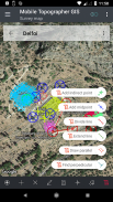
Mobile Topographer GIS is a mobile application designed for professionals in the field of surveying and geographic information systems (GIS). This app enables users to conduct surveys without limitations regarding the complexity or volume of data. Available for the Android platform, users can easily download Mobile Topographer GIS to access its extensive features.
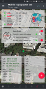
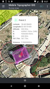
The app supports a range of GNSS readings, enhancing accuracy through the use of multiple satellite systems, including GPS, GLONASS, Galileo, Beidou, and QZSS. Users can connect external GNSS receivers, utilizing Mobile Topographer GIS as a processing unit for their data collection needs. The application allows for the display of data in either WGS84 or local projected coordinate reference systems (CRS), with seamless conversion capabilities between the two.
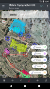
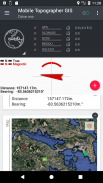
Real-time projection on the map enhances the user experience, providing immediate feedback during surveying tasks. A new feature in the app allows users to set a custom image or WMS server as a map background, allowing for personalized mapping experiences. The "Drive me" function helps users locate marked points in the real world, facilitating efficient navigation during fieldwork.
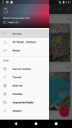
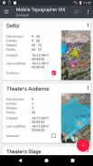
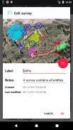
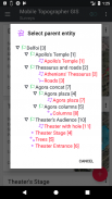
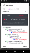
Mobile Topographer GIS also incorporates advanced height calculation tools, enabling users to compute orthometric heights on the fly utilizing the EGM model or local elevation grids, where available. Users have the capability to organize their work into distinct categories, such as Points, Shapes, Entities, and Surveys. This structure allows for the creation of individual points, multi-point groups, multipart polylines, and multipart polygons with holes, providing flexibility in data organization.
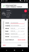
The app introduces geodetic tools for adding indirect points through various options, including combinations of distances and azimuths. Users can nest jobs to any level, creating super-surveys that enhance project organization. Additionally, data sharing between jobs is made possible with active links, promoting collaborative efforts among team members.
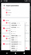
Import and export functions support exchanging jobs between mobile devices and desktop computers, accommodating all common formats such as .txt, .csv, .kml, .gpx, .dxf, and Shape files (.shp, .shx, .dbf). This interoperability ensures that users can efficiently manage and transfer their data across different platforms.
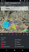
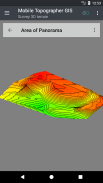
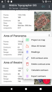
Mobile Topographer GIS also allows for the creation of 3D terrain models simply by walking through an area, offering a hands-on approach to terrain visualization. Users can calculate contours rapidly and incorporate them into their surveys, streamlining the data collection process. The app provides the capability to view a real 3D model directly on the device, enhancing the understanding of spatial relationships within the surveyed area.
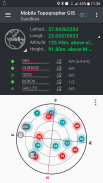
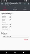
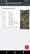
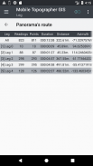
Route storage with accompanying data adds another layer of utility, allowing users to keep track of their paths and relevant information for future reference. The app also displays GNSS satellites along with signal information, presented in both a compass view and augmented reality (AR), providing users with valuable insights into satellite tracking.
Mobile Topographer GIS is designed with flexibility and functionality in mind, catering to the diverse needs of professionals in surveying and GIS. The app’s comprehensive suite of features supports a wide range of surveying tasks, from data collection to advanced geodetic operations, ensuring that users have the tools necessary for efficient project execution.
For those looking to explore the capabilities of Mobile Topographer GIS, a three-day free trial period is offered, allowing potential users to experience its functionality before committing to a subscription. During this trial, users will be required to provide billing information, but they will not incur any charges if they cancel within the three days. This approach enables users to evaluate the app's offerings without financial risk.
In the current era of mobile surveying, Mobile Topographer GIS stands out as a robust solution for professionals seeking to enhance their surveying capabilities. Its wide array of tools and features fosters an environment of efficiency and precision in data collection and analysis. The ability to integrate with external GNSS receivers, coupled with the support for various file formats, positions the app as a valuable resource for those in the surveying and GIS fields.
For more information about Mobile Topographer GIS, users can visit the official website or download the user manual to familiarize themselves with the app’s extensive functionalities. With its user-friendly interface and powerful capabilities, Mobile Topographer GIS is poised to meet the demands of modern surveying practices.
Find more about Mobile Topographer GIS in:
http://applicality.com/projects/mobile-topographer-gis/
Download the user's manual from:
http://applicality.com/app_documentation/web/MobileTopographerGIS_Manual.pdf
Mobile Topographer GIS - Version 6.0.15
(23-06-2023)

Mobile Topographer GIS - APK Information
APK Version: 6.0.15Package: com.applicality.mobiletopographergisLatest Version of Mobile Topographer GIS
Other versions


Apps in the same category

You may also like...


